|
A Guided Tour
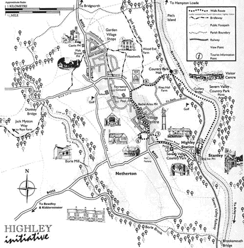
Highley occupies a commanding position on dividing the picturesque but contrasting valleys of the Severn and Borle Brook. The countryside can be easily explored using the many way-marked paths shown on the map
This is a short walk of 1.5 or 2.5 miles and provides a sample of what the area has to offer. The start point is Highley Station (point 1 on the map); if arriving by car, park at the Country Park (point 2). As you walk, look out for the sculptures that form the Discovery Trail. Take a leaflet from the station to learn more about them.
You can view the map by clicking here, or on the map icon next to any map reference point in the text.
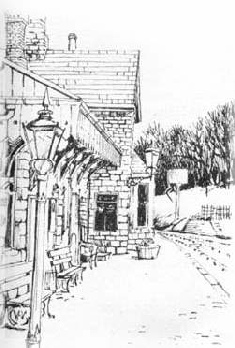
1 - Highley Station (Fig 1)
Opened in 1862, Highley Station lies on the country’s premier steam railway and has won many awards. Walk up the driveway and cross Station Road to pass through the gate opposite (next to the sign entitled Highley Mine).
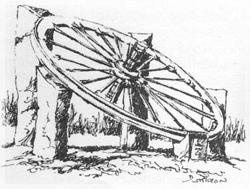
2 - Severn Valley Country Park (Fig 2)
Follow the path through a rocky cutting which was the line of a railway taking coal from the colliery to the station. Halfway up the hill, turn left and follow the path through the park to the mining wheel sculpture. This is dedicated to over 1000 men who worked here. The only other reminder of the colliery that operated between 1879 to 1969 is the office block, or ‘flats’, on the far side of the car park. The whole of this area together with the rest of the Country Park was formed from the spoil of the mine in the late 1980’s. Walk through the car park and turn left onto Station Road.
3 - Smoke Alley
Turn right into the path just before the bungalows start. The old sandstone cottages (Smoke Alley) date from 1800 and housed quarrymen, a reminder of Highley's quarrying past. Further up, the brick Rose Cottage was home to the village wheelwright. The timber-framed Oak Cottage to the left dates from the early 17th century. Turn left onto the main road, then cross to enter the Churchyard to the right.
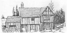
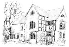
4 - Highley Church and Church House (Fig 3)
On entering the churchyard, stop to look back across the main road at the 16th century Manor House. This area formed the centre of the original village. As you walk towards the Norman church, you can see the late medieval Church House, the original home of the priest. The church is usually open during daylight hours and contains work from many periods. Turn to the left in front of the church and pass through the opening at the side of Church House into Church Lane. Walk down this lane, alongside the long brick farm building, across to the stile in the hedge and enjoy the view to Netherton and the Clee Hills.
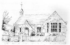
5 - Parish Hall (Fig 4)
Retrace your steps to Church Lane and follow the lane past the church until meeting the main road. The stone building on the corner was originally the village school, built in 1863. It has now been refurbished by voluntary effort to form the Parish Hall. Turn left along the main road up into the village. centre.
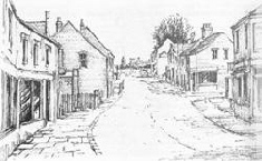
6 - Village Centre (Fig 5)
The transformation from an agricultural to a mining village is immediately apparent as you enter the High Street. This area dates from the turn of the century and is remarkably intact. A recent enhancement scheme has brought out its character. It now has attractive seating areas with shops and takeaways, some open 7 days a week and late in the evening. Silverdale Terrace was the first road built in 1885. Those with an interest in industrial villages should walk to the end of Silverdale Terrace and contrast the villas in Church Street built to house the officials with the terraces elsewhere! You will also be rewarded with fine views towards the Clee Hills at this point. Continue up the High Street.
7 - The Miner’s Welfare Ground
By the Welfare Ground you enter that part of the village created between the wars. The ‘Welfare’ was originally laid out in the 1930’s and now boasts a number of facilities including an open-air swimming pool, now part of the new Severn Centre. Turn right into Vicarage Lane opposite the ‘Welfare’.
8 - Vicarage Lane (Fig 6)
This pleasant, hedged lane leads you past the old vicarage, which dates from the 1620’s. Note the row of large, unusually-shaped beech trees, known locally as the Seven Sisters. Walk down Vicarage Lane and cross the railway.
9 - Country Park Halt
You can board the Severn Valley Railway to Highley Station or follow the river for a mile. This area was, until 1969, a coal preparation plant with coal brought via an aerial ropeway over the Colliery Bridge. An exhibition in the Visitors’ Centre, across the Colliery Bridge, shows how the area used to look. Refreshments are usually available at weekends here. The Colliery Bridge can be reached by following any of the paths to your right from the halt. Beyond the bridge, follow the riverside path through the woods, past the golf course to Stanley.
10 - Stanley
This community grew up based on the river when it was the main transport artery. Quarrying and mining took place here. Highley’s first pub, The Ship, opened in 1770. Turn right before The Ship to return to the station. The energetic can extend the walk by following the field path from the church (point 4) to Netherton, down the lane towards Borle Mill, taking the path to the right before the bridge is reached. The path follows very attractive woodland, rich in fauna and flora. The Donkey Bridge and ford at New England should be visited. Return to the village via Bind Lane and Bridgnorth Road.
If you have enjoyed this walk, a further 9 are described in “Walks around Highley” which is available from local shops or on request from the Highley Initiative at £2.00.
|
|
|
|